


oingt0309

jpfrobert
User
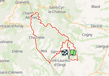

Length
41 km

Max alt
712 m

Uphill gradient
772 m
Km-Effort
52 km

Min alt
273 m

Downhill gradient
770 m
Boucle
Yes
Creation date :
2017-09-03 00:00:00.0
Updated on :
2017-09-03 00:00:00.0
3h00
Difficulty : Medium

FREE GPS app for hiking
 SityTrail
IGN / Geographical institutes
SityTrail Plus
The world is yours!
About
Trail Other activity of 41 km to be discovered at Auvergne-Rhône-Alpes, Rhône, Val d'Oingt. This trail is proposed by jpfrobert.
Positioning
Country:
France
Region :
Auvergne-Rhône-Alpes
Department/Province :
Rhône
Municipality :
Val d'Oingt
Location:
Oingt
Start:(Dec)
Start:(UTM)
622710 ; 5089610 (31T) N.
Comments